by Nina Dengg, Team Magdeburg
While there has been much writing about travel on roads here at Viabundus, we still haven’t addressed the question of what medieval land roads actually looked like.
In contrast to the road system in medieval cities, where we already have early evidence for paved roads, the medieval country road system was known for its bad condition (if anything is known about it at all). This is certainly due to the fact that, among other things, in most cases they were unpaved, and were therefore prone to change. The circumstance that prominent medieval writers such as Gregory of Tours tend to complain about the bad condition of the roads rather than praise them may have done the rest.
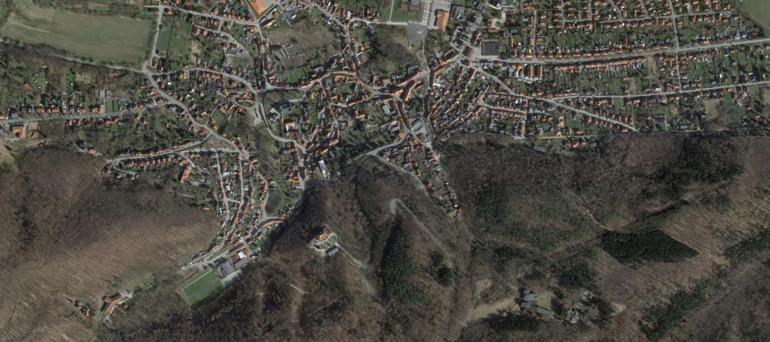
However, the appearance of the roads was highly variable: it depended on the travelers, the type of use, the weather conditions and the seasonal climate. Because of the flexible nature of the paths, in some places the roads fanned up into wide path bundles, which are characterized by several parallel routes in the terrain and also influenced the location of land use and territorial boundaries. Generally, we can at least state that in areas with greater landscape relief and steep slopes, high valley shoulders or terraced edges were chosen to move on, in order to avoid mountainous areas. In most cases, paving the road only became necessary as soon it was used by vehicles that were not suited for using the bare subsoil. For this reason, roads can usually only be attested archaeologically when they were designed for carts or wagons.
In the following, I will show some typical road types that have been uncovered by archaeological finds. Most of them were in use during the Middle Ages throughout Europe and left traces in the terrain until today. However, it must be noted that most archaeological finds of road constructions cannot be dated and thus not all types of roads can clearly be placed into the Middle Ages. Moreover, several road construction techniques were used until Early Modern times or even longer, so remains of old road construction do not necessarily point to ancient or medieval roads.
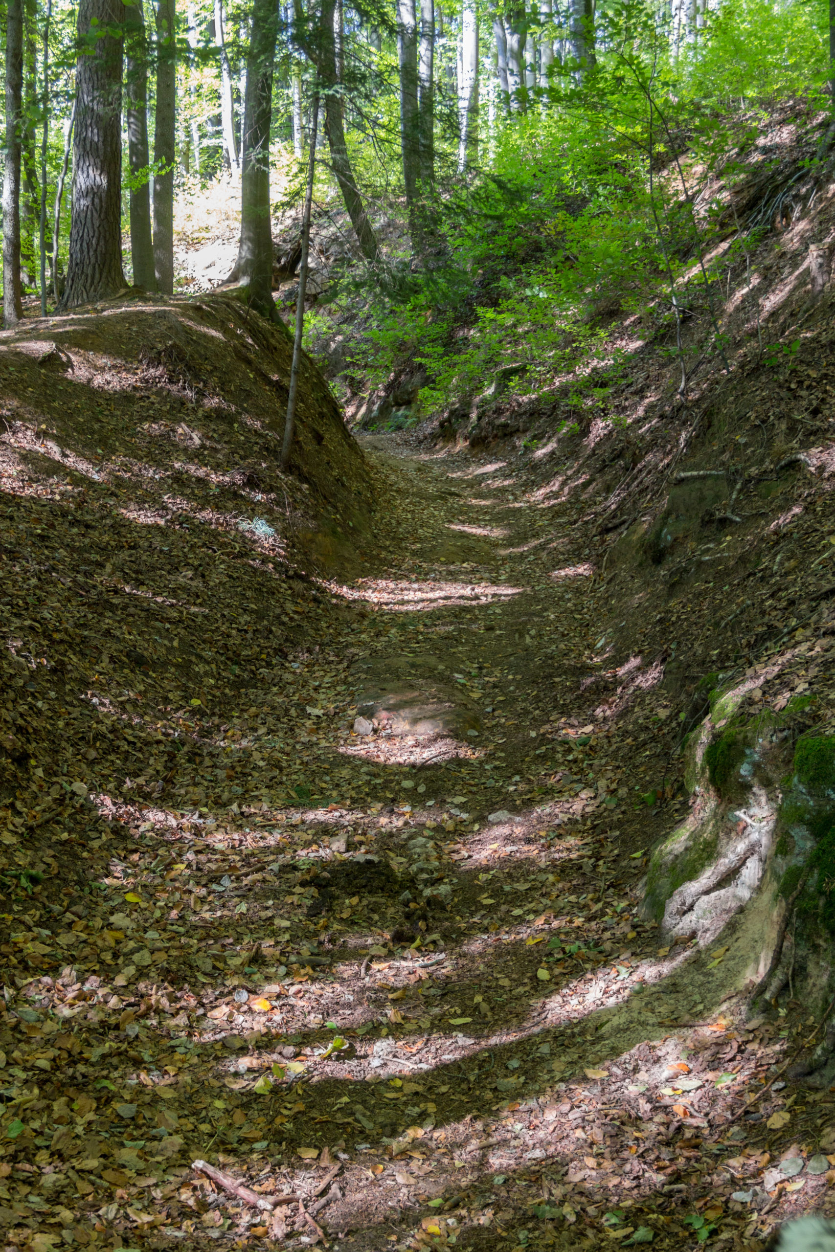
Holloways
In areas with already steep gradients, the aforementioned road bundles with several muddy, parallel roads were the focal points for erosion: The routes were washed out by precipitation and left clear depressions in the soil. Another characteristic of these so-called holloways (‘Hohlwege’) is their course on slopes: In most cases, they run far apart in steeper areas and converge again in shallower landscapes. Due to the comparatively fast formation and the long period of the use of holloways, which may even extend into modern times, the only way to receive exact datings of holloways is through archaeological excavations, which are rarely done. Even then, the chance of collecting any datable finds is rather small. Through terrain findings, a relative classification can be attempted, since routes often cross each other, and the resulting overlay hints at their sequence. Holloways are clearly identifiable and can be found throughout Europe; they are therefore a landmark that people can look out for during their next walk in the woods!
So far, neither written nor archaeological sources show how the use of holloways was organized, since they were usually only broad enough for one cart to pass. It would have been impossible for opposing carts to evade one another within such a holloway. In some cases, sources hint at times of day in which roads were allowed to be used in only one direction. It is also possible that there were individual farmsteads at the ends of the slopes, whose purpose it was to regulate traffic on this section of the road.

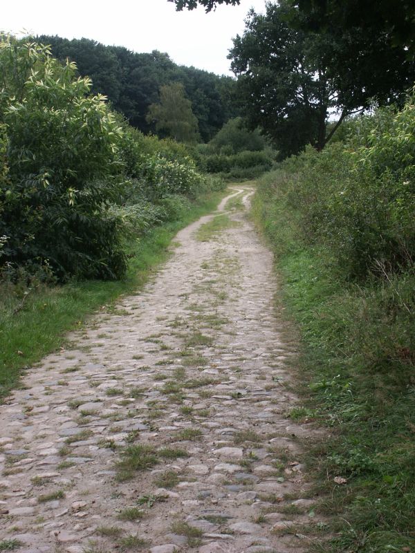
Paved roads
The well-paved, extensive road system of the Roman Empire and its efficiency is commonly known. It is all the more astonishing that this system appears to not have been maintained and used in the Middle Ages (also see our blog post from 12th August 2020).
It seems that the relics of Roman roads were often deliberately avoided in the Middle Ages – at least by carts. Possibly, the paved roads had unsafe surfaces for carts and draught animals, especially in wet conditions. Instead, unpaved roads formed parallel to the road, which increasingly deepened into holloways, as can be seen by Roman pavings that have been found in the banks of holloways.
In fact, little is known from written sources of the medieval long distance traffic network before the 12th century. There are isolated accounts on roads from the early Middle Ages that tell of the trimming of hedges and trees along the roadside, the paving of roads with wood or the filling of potholes, but these are very sporadic.
From the 12th century onwards, an increased preoccupation with the expansion of the road network can be observed. Roads were increasingly seen as a fiscal and political tools (by the levying of tolls on traffic), which went hand in hand with their maintenance and pavement. The main construction materials used to pave roads were wood, gravel or cobblestones, which occurred in combination with various structures such as drainage ditches, retaining walls, as well as bridges over water or valleys. Existing roads were also repaired, with potholes often filled in rather makeshift with earth and brushwood. Although these measures may seem quite minimal, they also offered advantages over paved roads for draught and riding animals: the surface had more grip and was less susceptible to frost, which could crack pavements open again. In the archaeological study of road construction techniques, it seems that there were also strong regional differences in the maintenance of the roads, which were related to the natural resources and geographic conditions in the area: Thus, in archaeological rural road evidence in northern Europe and northern Germany, roads were very often paved with wooden planks, while in the South of Germany the use of gravel for the paving of difficult road sections was more common. Other techniques, such as the construction of road ditches or the repair of potholes with respective materials may have been applied rather universally.
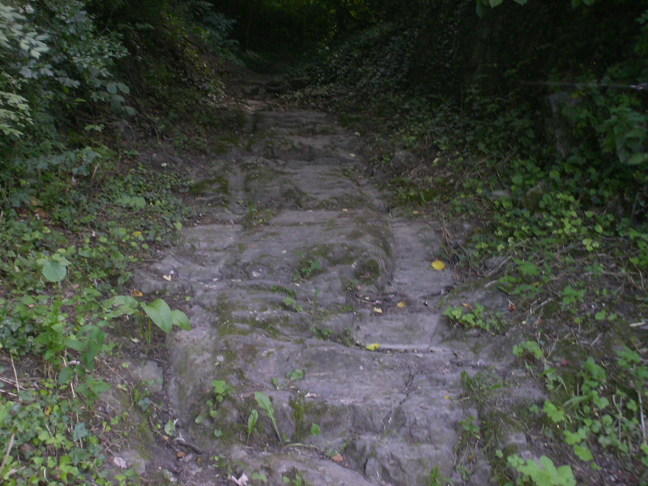
Track roads
Already in medieval sources, the German term “Geleis” is documented as a clear wheel track in the road. Such tracks marked, among other things, existing paths and could hinder progress due to the severe rutting of the ground. At the same time they also offered the possibility to move more easily with a cart. The tracks were created either by the frequent use of roads by heavy carts and wagons, which dug themselves into the ground, or they were intentionally hammered into stone. Especially in the alpine area, track roads (‘Geleisestraßen’) are found, which consist of two parallel grooves notched into a rock surface and thus fixed the lane for wagons and carts. This eased the descent of a slope for these vehicles, because before the invention of brakes a descent had to take place by blocking of at least one wheel and a vehicle was accordingly rather dragged downward than driven; by channeling the tracks, this procedure could take place in a more controlled way. This construction method also facilitated the ascent of a road: since the wheels encountered less friction in the often wedge-shaped tracks, pulling the wagon became easier for the animals; furthermore, driving on tracks was generally less bumpy.
Depending on the subsoil into which a track road was cut, tracks were subject to frost or weathering; on some roads, clear traces of repair can be found in the form of overturned paving stones, so that the older tracks are preserved on the sides of these stones. If a repair was no longer worthwhile, it could often happen – especially downhill – that several track lines lay next to each other, which were used one after the other within an assumed span of 15-20 years. However, the creation of track roads involved a considerable amount of work and caused many additional problems. For not only does the same question of right of way and control arise as with holloways, but the uniform spacing of the tracks meant that only certain carts with the appropriate gauge could use them. It can therefore be assumed that such track roads are related to a standardization of wheel spacing. So far, however, such a standardization is only known for the late Middle Ages, which makes it difficult to date these tracks.
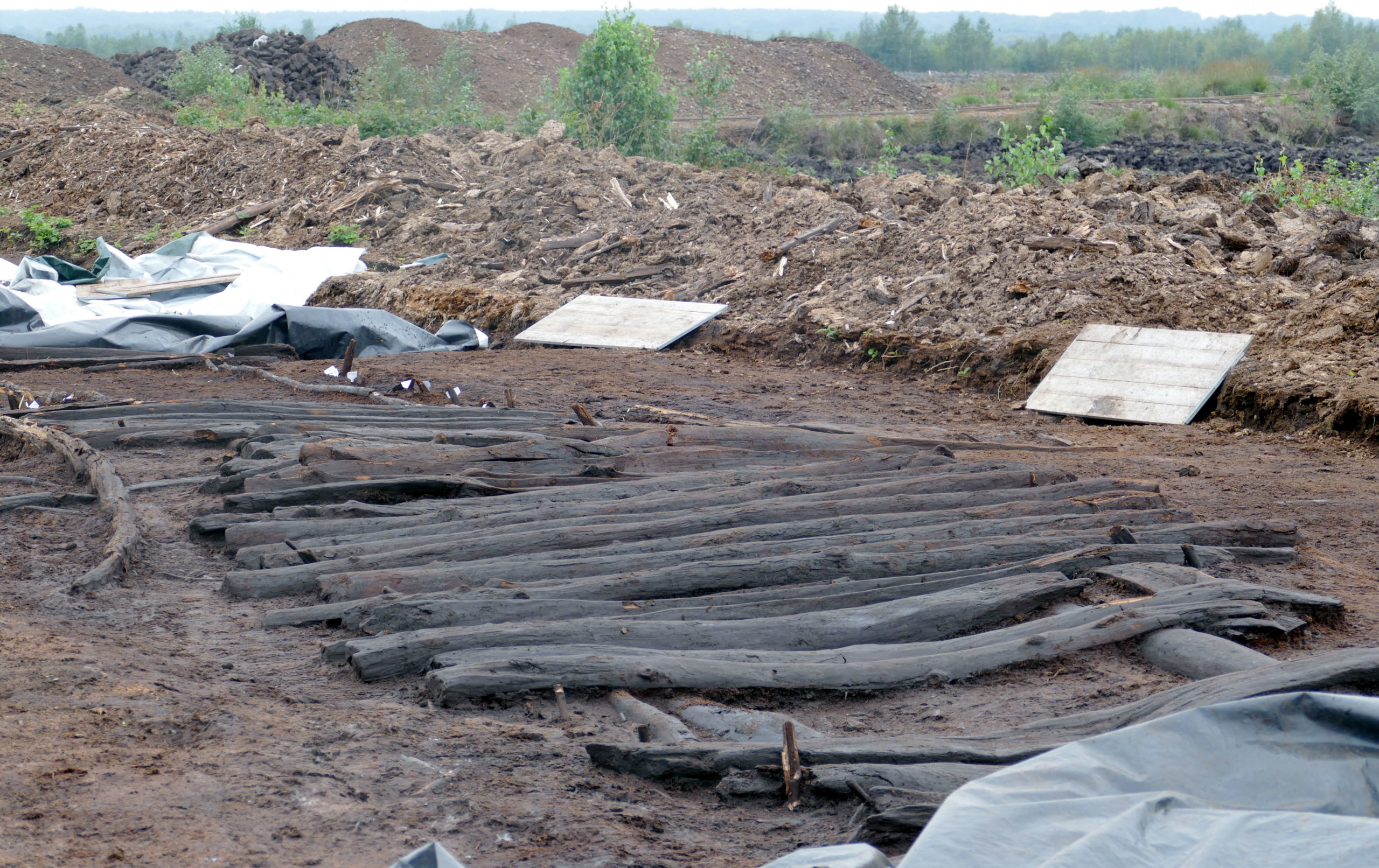
Boardwalks
Boardwalks, i.e. paths that were paved with wooden plank constructions, are already known from prehistoric times. In the Middle Ages, this type of path reinforcement through wetlands and bogs is documented mainly in northern Europe or northern Germany, although this is mainly due to the excellent preservation of wood in boggy regions. Since most boggy areas have been drained today, it can be assumed that planks for crossing wetlands were commonly used in most areas but have not been preserved. It is often assumed that the boardwalks stretched through an entire wetland or connected various dry sections in it, forming a network of paths. In most cases, it is possible to identify multi-phase and multi-layered structures that were continuously used and repaired over longer periods. This became necessary due to the damp underground and the associated sinking of the path into the moor, as well as the general weathering of the wood. Archaeologically, this circumstance offers the unique opportunity to date paths through methods from the natural sciences, such as radiocarbon dating.
Interestingly, wheel tracks are rarely found on planks, although it can be assumed that such elaborate paths were not only laid out for use on foot: especially in Slavic areas, boardwalks connected central places, between which heavier transport would have taken place. However, one should consider the possibility of other means of transport in such wet areas such as waterways, since the construction and maintenance of a boardwalk requires large quantities of wood, which had to be extracted from the surrounding area or imported. Transporting the wood to the actual construction site presented a transportation issue all of its own.
Further reading:
Denecke, Dietrich, Methoden und Ergebnisse der historisch-geographischen und archäologischen Untersuchung und Rekonstruktion mittelalterlicher Verkehrswege
. in: Herbert Jankuhn und Reinhard Wenskus (ed.), Geschichtswissenschaft und Archäologie. Untersuchungen zur Siedlungs-, Wirtschafts- und Kirchengeschichte, Vorträge und Forschungen des Konstanzer Arbeitskreis für Mittelalterliche Geschichte 22 (Sigmaringen 1979), 433-483.
Schreg, Rainer, Verkehr und Umwelt. Herausforderungen und Interessenskonflikte in Mittelalter und früher Neuzeit
, in: Thomas Fischer und Heinz Günter Horn (ed.), Straßen von der Frühgeschichte bis in die Moderne. Verkehrswege – Kulturträger – Lebensraum, ZAKMIRA-Schriften 10 (Wiesbaden 2013), 147-167.
Szabó, Thomas, Die Straßen in Deutschland und Italien im Mittelalter
. in: R. C. Schwinges (ed.), Straßen und Verkehrswesen im hohen und späten Mittelalter. (Ostfildern 2007), 71 – 118.
I love this project – the maps and the blog both!
Keep it coming – thanks for making it Creative Commons!
SB
Pingback: Travel in Medieval England - Medieval History
Awesome article. I wonder how many kilometers of roman roads are waiting to be discovered in Europe. Is amazing how they build it so durable. But unfortunately many roads were covered by dirt during the centuries or the stone was used for buildings.
Thank you this was very helpful for a blog post I’m writing.