By Nina Dengg, Team Magdeburg
The Viabundus project initially aims to map the Hanseatic road system. It stretched from the Netherlands all the way to Russia and from Denmark to Czechia. One can rightly say that a truly European road system was established and used, not to mention the connections that existed via sea routes.
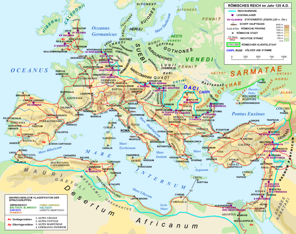
But this is only the perspective of the Hanse: Pan-European road systems are much older and have connected Europe since Antiquity. The most famous example would be the imperial road system that the Romans maintained, which stretched from the westernmost tips of Europe, along the Mediterranean, including the North African colonies all the way to the Levante during its Golden Age. The clearly organised structure of the Roman road network has attracted much attention from researchers, resulting among others in the ORBIS digital map of Roman roads, which has been an important source of inspiration for the Viabundus project.
But what happened to this expansive road system? How come we can see the remains of Roman roads quite clearly until today in certain places, while in others they seem to have disappeared completely? The following thoughts are derived from my master’s thesis in which I worked on the (dis)continuity of the Roman road network in northern Italy, the Alps and southern Germany.
With the end of the Roman empire, the central administration that the Romans had so expertly perfected collapsed. Instead, local groups were on the move, commonly known as the Migration Period. Sources are scarce in these times and even though we know that this was a time of extreme mobility, we know almost nothing about the modes of travel these groups employed. Did these groups travel on former Roman roads? One can assume as much, even though some sources suggest that occasionally roads were intentionally demolished to not facilitate invasions into the crumbling Roman empire. However, the main problem with the highly developed Roman road system was its constant demand for maintenance. This maintenance used to be organized centrally within the Roman administration, but after its collapse, it seems that some roads fell into disrepair.
Archaeological evidence, however, suggests that the deterioration was not as immediate and final as some might believe; it depended more on whether the Roman roads still led to places of interest. The Roman road system had been constructed with fast troop movement and rapid messaging in mind. Therefore, Roman roads quite single-mindedly moved from A to B without considering smaller settlements on the side. These smaller settlements and their connections gained importance after the Roman period, when the central administration was replaced by several smaller, local administrations, such as bishoprics or fiefdoms. The scant archaeological evidence on roads in this period suggests that the Roman roads that fell within such local connections continued to be maintained, while passages that basically led in the wrong direction did not. In other words: with the shift towards a new network of administration, a new road network was needed. If the Roman roads served this new network, they were incorporated – if not, they decayed.
This explains why some Roman roads are known until today and that some of our modern roads even still follow the exact course of these roads, as the Roman plaster was used as a foundation for the modern pavement. One example was the Via Agrippinensis between Cologne and Jülich, which continued to be used through the centuries and still is the foundation of the modern German highway B 55. This also means that this former Roman road is included on the Viabundus map in that region. In other cases, merely the idea of the course of the Roman road remained until today and Medieval sources only mention old Roman roads that were still used, without giving information on its exact location.
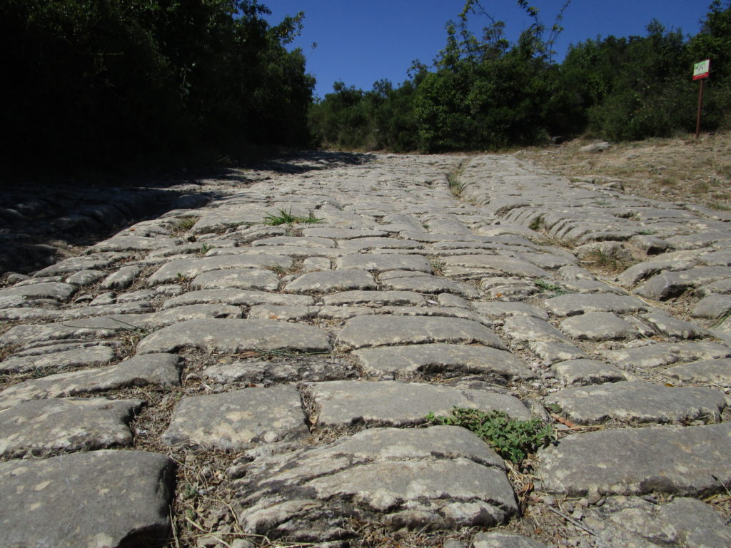
Even today there are footpaths and hiking trails that follow Roman roads. However, in this case one has to be careful – there is a tendency to quickly label historical paved roads as “Roman”, since only the Romans paved roads well until the Early Modern times, whereas medieval roads are commonly considered to have been mud trails. While this assumption proves to be correct most times (even though there were paved roads in Medieval times as well, but more on that in another post), research on historical paved roads in the Alps has shown that some of these assumed “Roman” roads turned out to be structures of (Early) Modern Times.
Keeping the constant maintenance that paved roads require in mind, one has to consider the possibility that the best-preserved Roman roads today may be those that were the least used during Medieval and Early Modern times. Regular use of a paved road means that a mud layer forms almost immediately (think of a garden trail after a good rain). After some time, roadside ditches fill in, paving stones get pulled out, puddles form, and people look for ways around them. Even if an existing road was followed originally, it may have soon been invisible in the landscape and travellers started to follow the general direction they thought the road should be in. Others followed and soon enough the course of the road had changed, leaving the original road buried beneath a layer of mud and earth. On the other hand, if such faults were repaired regularly, the road may be unrecognisable as a Roman road today. Either way, very thorough archaeological scrutiny may be the only way to uncover the original road.
These thoughts and observations show that road systems are highly flexible and the product of contemporary political and social developments. A map can only show a very static snapshot of a road system at a certain time. By giving the possibility to adjust the time in which the road system is viewed, the Viabundus map attempts to give an impression of the flexibility of road networks.
In the long run, Viabundus aims to show the development of several road systems in cooperation with partners across Europe. To this end, the Viabundus-team met up with Pau de Soto from the Mercator-e project in Barcelona, who records road systems all over Spain, as well as Stephen Gadd (London) who works on Elizabethan road systems in England, and finally Tomasz Panecki and Tomasz Związek (Polish Academy of Sciences in Warsaw) who work on the road systems in the Historical Atlas of Poland. Eventually, we hope to show the immense mobility that has occurred in Europe at all times and the ways such networks have transformed.
Further reading:
Esch, Arnold, Zwischen Antike und Mittelalter. Der Verfall des römischen Straßensystems in Mittelitalien und die Via Amerina (München 2011).
Henning, Joachim, “Strong Rulers – Weak Economy? Rome, the Carolingians and the Archaeology of Slavery in the First Millennium AD”. in: Jennifer R. Davis and Michael McCormick (eds.), The Long Morning of Early Medieval Europe. New Directions in Early Medieval Studies (Burlington 2008), 33 – 53.
Schwarz, Klaus, Archäologisch-Topographische Studien zur Geschichte frühmittelalterlicher Fernwege und Ackerfluren. Im Alpenvorland zwischen Isar, Inn und Chiemssee, Materialhefte zur Bayerischen Vorgeschichte, Reihe A, Band 45 (Kallmünz/OPf. 1989).
Hello,
Thanks for your work on Roman roads. I have been interested in them for the last 50 years. It occurs to me that in Britain the roads were used by armies and farmers until the industrial revolution, when even the best made roads would be damaged by the heavy use, hence the need for canals, railways and modern roads. Also, the stones of the Roman roads would be useful for building houses. The routes have often beeb preserved as houses and farms have been built along their course, but also bridges and causeways.
Thank you for your comment and the view from Britain. We look with envy at the tradition of preservation and research into roads. Historical geography died out in Germany, it is being taught at just one minor university. Historical societies just now realize how important and attractive the topic of old roads is for local research. Do you know the (very) new mapping project viae regiae about British roads (mainly from 16th century onwards, though)? Perhaps you’d like to contribute: https://viaeregiae.org