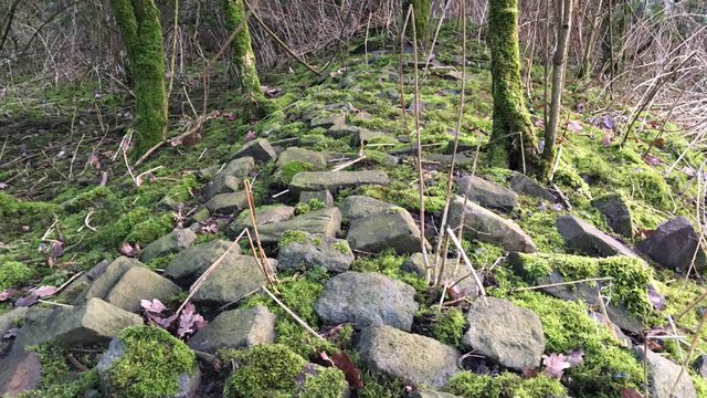
In April this year, volunteers of the local tourist organization in Gavere near Gent, Flanders, discovered the overgrown remains of a late medieval paved road near the village of Asper by chance. They were planning a historical walking tour and saw that on old maps (1669) a road was drawn which did not exist anymore. Visiting the site, they discovered the setts (stones) of the former road under the earth and bushes.
Most pre-modern road remnants take the form of hollow roads, where the road lies deeper than the surrounding land, carved out from the earth’s surface by centuries of continuous use (see for example the image in the blog’s header). The find of the Flanders road is exceptional in that it is the opposite of a hollow road: the paved road surface is located on a higher level than the surrounding land. Roads like these were constructed in terrain that was marshy or prone to flooding, designed to prevent the road from turning into a mud pool.
The map that is being created by the pre-modern streetmap project is also intended to cover a part of Flanders. If we will find someone to work on a Flemish sub-project (volunteers welcome!), the newly discovered road might be included on the map as well. At least the find shows us that when trying to reconstruct medieval roads, it is sometimes worth going into the field in addition to studying old maps and written sources.
Original article (in Dutch) here: https://www.vrt.be/vrtnws/nl/2019/04/24/middeleeuwse-snelweg-gavere-bij-toeval-ontdekt/